Bus Rapid Transit Program

Get Bus Rapid Transit Updates
Subscribe to receive Bus Rapid Transit updates directly to your inbox! Learn more about program milestones, engagement opportunities, and events. You may unsubscribe at any time.
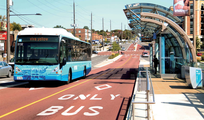
Bus Rapid Transit (BRT) will bring fast, frequent, and reliable service to more communities across the region—sooner. With dedicated lanes, transit signal priority at intersections, and weather-protected stations, BRT helps you get where you need to go faster and more comfortably.
To deliver these benefits, TransLink and the Mayors’ Council have identified nine BRT corridors. King George Boulevard, Langley–Haney Place, and Metrotown–North Shore BRT are the first three projects, now in detailed planning and community engagement.
These projects have preliminary funding through the 2025 Investment Plan. Additional funding will be needed to fully deliver them, and TransLink is working with all levels of government to secure support through future Investment Plans. Once fully funded, BRT projects can be built and in service within three years.
BRT is Metro Vancouver’s Newest Rapid Transit Experience
Get There Fast
Avoid unforeseen wait times and skip past traffic, so you can get to the people and places that matter most, faster.
Turn Up and Go
No need to pre-plan, check schedules, or worry about wait times. With BRT’s enhanced reliability and frequency, your experience couldn’t be easier: just turn up and go.
Peace of Mind
Ride with confidence on every BRT journey, knowing you’ll arrive safely, comfortably, and reliably – rain or shine, night or day.
BRT in the Access for Everyone Plan
The Access for Everyone plan includes an expansion of the region’s Major Transit Network by implementing approximately 170 kilometres of rapid transit on up to 11 corridors, nine of which have been identified as BRT corridors.
The nine BRT corridors include:
-
King George Boulevard
-
Langley–Haney Place
-
Metrotown–North Shore
-
Hastings Street
-
Lougheed Highway
-
Lynn Valley–Downtown/Lonsdale
-
Marine Drive Station–22nd Street Station
-
Richmond Centre–Metrotown
-
Scott Road
Priority BRT Corridors

The Mayors’ Council on Regional Transportation identified King George Boulevard, Langley–Haney Place, and Metrotown–North Shore as the first three corridors to advance to further planning, engagement, and implementation.
TransLink and local government partners are advancing necessary planning and design work and engage with the public on these three corridors. Although roadway designs, associated costs, and timelines have not yet been determined, business cases will be developed for each corridor to be included in an update to the Investment Plan, as these projects are currently unfunded.
King George Boulevard BRT

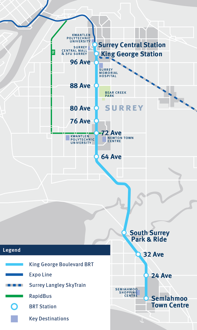
King George Boulevard BRT will introduce an additional 19 kilometres of rapid transit service to Surrey, featuring 12 stations. During peak hours, service will operate every 5 minutes, providing commuters with a convenient and reliable travel option.
This BRT service will provide a direct connection between Surrey City Centre and Semiahmoo Town Centre, reducing travel time by 40% to approximately 40 minutes. Key destinations accessible by this route include Surrey Memorial Hospital, Bear Creek Park, Newton Centre, and South Surrey Park and Ride.
The King George Boulevard BRT will also provide seamless connections to local routes, ensuring fast and convenient transfers. Additionally, it will improve access to SkyTrain, including the future Surrey Langley SkyTrain.
Building on the success of the existing R1 King George Blvd RapidBus, the King George Boulevard BRT will enhance transit accessibility across the region. Upon its launch, the R1 RapidBus service from Surrey Central to Guildford Exchange will be replaced by equally frequent local service between Guildford, Surrey Central, and Newton Exchange.
Langley–Haney Place BRT

Langley–Haney Place BRT will establish a 22-kilometre rapid transit connection between the Township of Langley and Maple Ridge, featuring 13 stations. During peak hours, service will operate every 10 minutes, providing commuters with a convenient and reliable travel option.
This BRT service will provide a direct connection between Willowbrook and Haney Place, reducing travel time by more than 40% to approximately 40 minutes. Key destinations accessible on this route include Willowbrook Shopping Centre, Langley Events Centre, Carvolth Exchange, Ridge Meadows Hospital, and Haney Place.
Langley–Haney Place BRT will also connect to the future Surrey Langley SkyTrain at Willowbrook Station, the R3 Lougheed Hwy RapidBus, and Carvolth Exchange and Park and Ride.
Metrotown–North Shore BRT
Corridor length: 21 kilometres
The Metrotown–North Shore rapid transit corridor will connect major destinations such as Park Royal, Capilano Mall, Lower Lonsdale, Lower Lynn, Burnaby Heights, Brentwood, BCIT, and Metrotown. It will also improve connections to SkyTrain at Brentwood Town Centre on the Millennium Line and Metrotown Station on the Expo Line.
Recognizing the high transportation demand on this corridor, work has begun to extend the R2 Marine Dr RapidBus from Phibbs Exchange to Metrotown, providing a direct express connection between Burnaby and the North Shore. This will replace the limited, peak service 222 between Phibbs Exchange and Metrotown and provide all day service, higher capacity articulated buses, and enhanced stop amenities. For more information, visit the RapidBus page.
At the same time, an ultimate rapid transit connection will be determined through the Burrard Inlet Rapid Transit Program, which will plan for BRT and consider other rail alternatives. The study will evaluate technology, different route alignments, stop and station locations, and degree of roadway separation including options for a dedicated transit crossing of Burrard Inlet.
Priority BRT Corridors

The Mayors’ Council on Regional Transportation identified King George Boulevard, Langley–Haney Place, and Metrotown–North Shore as the first three corridors to advance to further planning, engagement, and implementation.
TransLink and local government partners are advancing necessary planning and design work and engage with the public on these three corridors. Although roadway designs, associated costs, and timelines have not yet been determined, business cases will be developed for each corridor to be included in an update to the Investment Plan, as these projects are currently unfunded.
King George Boulevard BRT

King George Boulevard BRT will introduce an additional 19 kilometres of rapid transit service to Surrey, featuring 12 stations. During peak hours, service will operate every 5 minutes, providing commuters with a convenient and reliable travel option.
This BRT service will provide a direct connection between Surrey City Centre and Semiahmoo Town Centre, reducing travel time by 40% to approximately 40 minutes. Key destinations accessible by this route include Surrey Memorial Hospital, Bear Creek Park, Newton Centre, and South Surrey Park and Ride.
The King George Boulevard BRT will also provide seamless connections to local routes, ensuring fast and convenient transfers. Additionally, it will improve access to SkyTrain, including the future Surrey Langley SkyTrain.
Building on the success of the existing R1 King George Blvd RapidBus, the King George Boulevard BRT will enhance transit accessibility across the region. Upon its launch, the R1 RapidBus service from Surrey Central to Guildford Exchange will be replaced by equally frequent local service between Guildford, Surrey Central, and Newton Exchange.
Langley–Haney Place BRT

Langley–Haney Place BRT will establish a 22-kilometre rapid transit connection between the Township of Langley and Maple Ridge, featuring 13 stations. During peak hours, service will operate every 10 minutes, providing commuters with a convenient and reliable travel option.
This BRT service will provide a direct connection between Willowbrook and Haney Place, reducing travel time by more than 40% to approximately 40 minutes. Key destinations accessible on this route include Willowbrook Shopping Centre, Langley Events Centre, Carvolth Exchange, Ridge Meadows Hospital, and Haney Place.
Langley–Haney Place BRT will also connect to the future Surrey Langley SkyTrain at Willowbrook Station, the R3 Lougheed Hwy RapidBus, and Carvolth Exchange and Park and Ride.
Metrotown–North Shore BRT
Corridor length: 21 kilometres
The Metrotown–North Shore rapid transit corridor will connect major destinations such as Park Royal, Capilano Mall, Lower Lonsdale, Lower Lynn, Burnaby Heights, Brentwood, BCIT, and Metrotown. It will also improve connections to SkyTrain at Brentwood Town Centre on the Millennium Line and Metrotown Station on the Expo Line.
Recognizing the high transportation demand on this corridor, work has begun to extend the R2 Marine Dr RapidBus from Phibbs Exchange to Metrotown, providing a direct express connection between Burnaby and the North Shore. This will replace the limited, peak service 222 between Phibbs Exchange and Metrotown and provide all day service, higher capacity articulated buses, and enhanced stop amenities. For more information, visit the RapidBus page.
At the same time, an ultimate rapid transit connection will be determined through the Burrard Inlet Rapid Transit Program, which will plan for BRT and consider other rail alternatives. The study will evaluate technology, different route alignments, stop and station locations, and degree of roadway separation including options for a dedicated transit crossing of Burrard Inlet.
Program Timeline
Phase 1
BRT Customer Experience Engagement
Read the summary here.
Summer 2024
Phase 2
BRT Features Engagement
(King George Boulevard and Langley-Haney Place BRT)
Read the summary here.
Jan. 16 - Feb. 9, 2025
Metrotown–North Shore BRT
Features and Route Options Engagement
Summary coming early 2026
Aug. 25 - Sept. 21, 2025
Learn About North American BRT Systems

BRT systems can be found in more than 200 cities around the world. By introducing BRT, our region is following in the footsteps of communities that have successfully leveraged their systems to improve transit reliability, shorten travel times, reduce congestion, support economic development, and build new housing. Learn about North American examples by playing the videos below.
York Region, Ontario (Viva BRT)
Montreal, Quebec (Pie-IX BRT)
San Francisco, California (Van Ness BRT)
Oakland, California (Tempo BRT)
Resources
Reports
Contact Us
Please email the project team at brt@translink.ca if you have any question or comments about the Bus Rapid Transit Program.
Your information is collected in accordance with s.26(e) of the Freedom of Information and Protection of Privacy Act. If you have any questions, please contact brt@translink.ca.

